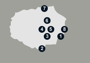
A Galápagos Islands visit is an unparalleled personal experience with the natural world, best uncovered by an expeditionary Galápagos cruise or private charter.
Bordered by sheer cliffs that rise to the east, north, and south, the dry, basaltic plateau now known as the island of Baltra was once connected to Santa Cruz and Seymour Islands. Today, it is a military base and not part of the Galápagos National Park. However, it has docks and one of the two airports in the islands that receive flights from the mainland (the other airport is on San Cristóbal Island). Baltra is connected to the island of Santa Cruz by a ferry that daily crosses the Itabaca Channel between the islands.
Other than the airport, there are no visitor sites on Baltra.
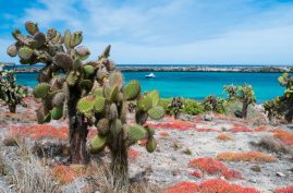
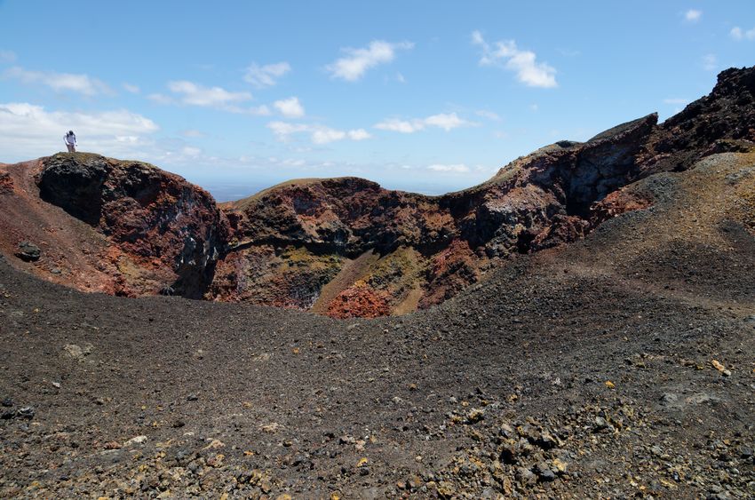
If you’ve ever wondered what it would be like to visit the moon, Bartolomé might just provide you with the answer. An extinct volcano, Bartolomé Island appears to be geology in its purest form: The island is dotted with craters, cinder cones, lava flows, spatter cones, and broken lava tunnels which run down from the summit. And just offshore is Pinnacle Rock, the tuff cone that is probably the most famous landmark in the Galápagos. Although at first glance, words that describe a moonscape — such as barren and desolate — might come to mind, Bartolomé supports a starkly beautiful complex of life. Some Arid and Littoral Zone plants have taken hold. On the slopes of the volcano, low-to-the-ground gray matplant thrives in the volcanic sand; and spurge, which forms a small tuft of green with tiny, white flowers, pushes up. Endemic lava cacti adorn some of the older lava.
Pinnacle Rock: Pinnacle Rock is an eroded volcanic formation that juts from the sea like an obsidian knife. It is truly an iconic site and is one of the best-known and most photographed sites in the islands. After landing on the beach adjacent to the rock, visitors can swim with colorful fish, sea lions, Galápagos penguins and can swim and snorkel around the rock itself. A short trail leads to a beach to the south where swimming is prohibited, though you may see stingrays, spotted eagle rays and black tipped sharks. The northern beach is a nesting site for green sea turtles from January to March. Landing: Dry.
Opposite Pinnacle Rock is another landing site. Visitors climb an 1800-foot trail to the 600-foot summit of the island. Much of the trail is a wooden staircase, built to prevent erosion. Along the way, you will notice many interesting volcanic formations including spatter and tuft cones and lava flows. The summit provides stunning views of Pinnacle Rock, Sullivan Bay, and Daphne Major and Minor. Landing: Dry.
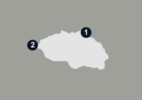
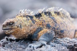
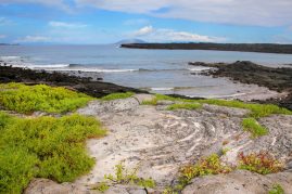
At 3.4 million years, Española is the oldest of the Galápagos Islands. With its breadth of one-of-a-kind wildlife and plant species, it truly embodies the spirit of the Islas Encantadas. Washed by surf and spray and bordered by steep cliffs, Española is probably the Galápagos you envisioned when you decided to make the trip to the islands. As the southernmost island in the archipelago, Española’s relative isolation has resulted in not only an abundance of unusual wildlife but species and subspecies that are endemic to the island itself, such as the Española (Hood) mockingbird, the Española (Hood) racer snake, the Española (Hood) lava lizard, the waved albatross, and the island’s brightly colored marine iguanas.
Along with this rich faunal life, the vegetation on Española is a blend of Littoral, Arid, and Transition Zone plants. Galápagos carpetweed and spiny shrubs, such as Galápagos lantana, bump up against each other here. Intertidal life bursts with green and pencil-spined sea urchins, angelfish, and sea anemones.
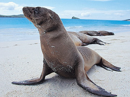
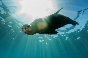
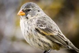
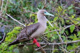
1) Gardner Bay: With an expansive white sand beach (one of the longest in the Galápagos), Gardner Bay is popular with tourists and sea lions alike. There is no trail here, so the main activities are wandering the tranquil beach and snorkeling and swimming. Three species of Darwin’s Finches and Española Mockingbirds (the only carnivorous mockingbird species) can be spotted here. From January to March, Green Sea Turtles can be found nesting on the beach. Landing: Wet.
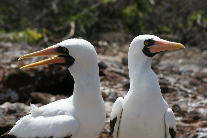
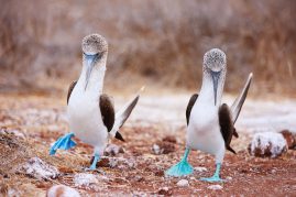
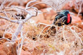
2) Punta Suarez: As you land at Punta Suarez on the western tip of the island, you may see young sea lions surfing the waves and colorful marine iguanas basking in the sun. Blue-footed and Nazca boobies nest just inland. A two-mile hike leads visitors past colorful Española lava lizards to the cliffs and the famous blowhole, which spurts water over twenty feet into the air at high tide. Between April and December, the world’s entire population of adult waved albatrosses (between 25,000 and 30,000 individuals) can be found nesting here. They mate for life and perform an elaborate mating dance that includes stumbling, honking, and beak-fencing. Landing: Dry.
3.) Osborn Islet: After landing, you can walk across a lovely white sand beach amongst a busy sea lion colony or dive into the water to swim with sea lion pups. This small island is a marine visit where you can enjoy fantastic snorkeling and swimming. Landing: Wet
Visiting Fernandina is like seeing the Earth when it was brand-new. The most westerly of the Galápagos Islands, Fernandina is the youngest and most active volcanically, with eruptions occurring from its single volcano, La Cumbre, every few years. Lava fields extend from La Cumbre’s base to the ocean, and both types of flows — `a`a (pronounced “ah ah”), and pahoehoe — can be seen. Fernandina is literally land-in-the-making.
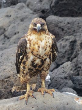
1) Espinosa Point: Here you may see some of the most unique Galápagos species: flightless cormorants, Galápagos hawks, Galápagos penguins, and the largest colony of marine iguanas in the islands. In 1994, Espinosa Point was raised between two and three feet by tectonic uplift, leaving the landing dock inaccessible except at high tide. Landing: Dry.
Best known for its colorful history, Floreana has seen the footsteps of buccaneers, pirates, whalers, convicts, and colonists on its shores. Because of a small spring that bubbles up from underground (which occasionally dries up) and a nutrient-rich soil, it was a haven for the early pirates and whalers in the seventeenth and eighteenth centuries — and later for more permanent residents. In fact, Floreana has been continuously inhabited since the mid-1800s and was the first of the Galápagos Islands to support a permanent human population.


1) Post Office Bay: In the eighteenth century, a group of whalers set up a wooden barrel to collect mail at this site, now known as Post Office Bay. A trail behind the barrel leads through palo santo and palo verde trees to a cave, which is actually a lava tube running down to the sea. Landing: Wet.
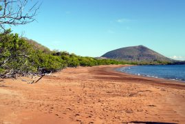
2) Punta Cormorant: Between two tuff cones, the Punta Cormorant landing is on a beach with green, olivine sand. Trails allow you to explore a brackish lagoon where greater flamingoes wade through the water, sifting shrimp with their curved bills. Stingrays can be seen in the shallows. You may also see pintail ducks, stilts, large-billed flycatchers, and several species of finches. Landing: Wet.
3) Devil’s Crown: Devil’s Crown is a volcanic crater that has been eroded by waves. The inside of the “crown” is a perfect environment for coral, which attracts other marine life; making this one of the best snorkeling sites in the Galápagos. You may see sea lions, sharks, rays, tropical fish, eels and sea turtles. The outside of the crown is a haven for birds including boobies, pelicans, frigatebirds, and red-billed tropicbirds. Landing: None.
4) Highlands: Cerro Alieri and Asilo de la Paz: There are two visitor sites in highlands of Floreana. Both are located at the base of Asilo de la Paz, a 300-foot volcanic cone. Cerro Alieri is about a 15-minute drive from Puerto Velasco Ibarra. Armchair botanists will enjoy learning about the 48 species of plants that have been identified here, 56% of which are native and 33% of which are endemic. In addition, this is the site of a major conservation program for a critically endangered plant, Linum cratericola, which was believed extinct until scientists and park wardens re-encountered it in 1997. Asilo de la Paz is about a 45-minute ride from town. Here, you may view a pirate cave and the freshwater spring that is the island’s main water source. A nearby corral, built by the national park service, contains giant tortoises from various islands. Landing: None.
Less than half a degree north of the Equator, Genovesa is often referred to as “Bird Island” for the vast numbers of pelagic seabirds that come here to nest. Great frigatebirds, red-footed boobies, swallow-tailed gulls, and storm petrels all breed here by the thousands. However, there are no land reptiles — with the exception of some very small marine iguanas. This is due to the direction of the ocean currents, which couldn’t carry the terrestrial animals here. The island itself is a low, shield volcano barely breaking the surface of the ocean. Ships sail directly into its large, breached caldera to anchor. Due to its remote location and lack of freshwater, Genovesa remains almost unaltered; there are no introduced species on the island.
1) El Barranco/Prince Phillip’s Steps: El Barranco is notable for its variety and abundance of birdlife including red-footed and Nazca boobies, short-eared owls, red-billed tropicbirds, Galápagos swallows and Galápagos doves. Upon landing on a steep rocky stairway, visitors are treated to the site of small fur seal colony and a variety of marine life clinging to the rocks. There is a hike (just under a mile) to a plateau that leads through a Palo Santo forest where you will pass nesting booby colonies. There are some great views of lava plains near the end of the trail. Keep an eye out for wedge-rumped storm petrels. Landing: Dry (with slippery rocks).
2) Darwin Bay: After landing on a white-sand, coral beach, you may embark upon a hike along a short trail (one half mile) that meanders through mangroves, where a variety of land birds may be spotted, to the tidal pools where sea lions are often found frolicking, and up a rocky hill that leads to a point overlooking the cliffs and Darwin Bay. This is one of the few places in the islands where you are pretty much guaranteed to see red-footed boobies and you may see white-cheeked pintail ducks, gulls, and herons feeding near the shores of the tidal lagoon. Landing: Wet.
Isabela is the largest of the Galápagos Islands, with more than half of the land surface area in the archipelago. It is made up of six volcanoes (Alcedo; Cerro Azul; Darwin; Sierra Negra; Wolf, which has the highest summit in the Galápagos at an elevation of 5,600 feet; and Ecuador, an extinct volcano that has been destroyed by erosion and wave action) that are joined by extensive lava flows. Along with Fernandina Island, it is one of the most volcanically active spots on earth. The Equator passes through both Ecuador and Wolf Volcanoes.
More wild giant tortoises live on Isabela than on any other island in the Galápagos. Isabela’s large size and volcanic topography created barriers for the slow-moving reptiles; they were unable to cross the lava flows, causing several different sub-species of tortoise to develop. Today, Galápagos giant tortoises roam free in the calderas of Alcedo, Cerro Azul, Darwin, Sierra Negra, and Wolf Volcanoes.

1) Puerto Villamil: The quiet, laidback town of Puerto Villamil is the main settlement on the island. The nearby beach and lagoons are the perhaps the best places in the archipelago to view migratory birds. Black-necked stilts and flamingoes are two of the most common resident species. You can reach several visitor sites from town, including:
• Tortoise Center: There is a one-mile interpretive trail that leads from town, goes past the lagoons, and ends at the Tortoise Center, which houses tortoises from the populations of southern Isabela.
• Wall of Tears is a 3.5-mile walk (one-way) from town. The wall was built by convicts at the penal colony that operated on the island in the 1940s and 1950s. The wall is 15 to 18-feet high, nine-feet wide and 300-feet long.
• Tintoreras is a group of small islets off the coast that are only accessible by boat. You may spot sea lions, sea turtles, marine iguanas, rays, and other species in the tranquil waters of the bay.
2) Sierra Negra Volcano: Sierra Negra’s caldera measures six-miles across from north to south and nine-miles across from east to west, making it the second largest caldera in the world! It is a 45-minute drive from Villamil, followed by several hours of walking or horseback riding. On the rim of the volcano, the trail divides into two: to the west, it heads to Mina de Azufre, an old sulfur mine; toward the east, the trail leads to Chico Volcano. The endemic narrow-leafed Darwin bush is found only around the rims of Sierra Negra and Cerro Azul. Landing: None.
3) Punta Moreno: The trail here crosses a large pahoehoe lava flow, dotted by numerous green lagoons, where flamingoes, paint-bill crakes, white-cheeked pintails and common gallinules can be seen. This young lava flow is in the process of being colonized by several species of interesting pioneer plants. Landing: Dry.

4) Elizabeth Bay: No visitors are allowed on land here, but a panga tour around the bay and adjacent lagoons may reveal Galápagos green turtles, golden cownose rays, spotted eagle rays, and white-tip reef sharks. Galápagos penguins prefer the rocky islets, and marine iguanas enjoy the plentiful algae. Other species seen here include flightless cormorants, pelicans, and lava herons. Landing: None (though snorkeling is permitted).
5) Urbina Bay: A trail leads away from the beach and into the arid zone of the island. Here you may encounter large land and marine iguanas and giant tortoises. Closer to the water you may see flightless cormorants. The most unique feature here is the miles-long stretch of coral reef jutting into the air – a result of a major uplift in 1954. Landing: Wet.
6) Tagus Cove: Early pirates and whalers frequented Tagus Cove and some even wrote their names on the cliffs along the shore. A short steep hike leads to Darwin Lake, which is comprised of salt water and lies within a tuff cone. It is a good place to spot a variety of land birds such as ground and tree finches, hawks, yellow warblers, large-billed flycatchers and, occasionally, woodpecker finches. A panga ride along the cliffs may reveal flightless cormorants, Galápagos penguins, and Galápagos sea lions. Landing: Dry (with slippery rocks).
7) Vicente Roca Point: At Vicente Roca Point in the north, remnants of an ancient volcano form two turquoise coves with a bay that is well protected from ocean swells. This is a popular anchorage from which to take panga rides along the cliffs that are the volcano’s remains or to explore a partially sunken cave at the water’s edge. Blue-footed and Nazca boobies perch along the sheer walls, while flightless cormorants inhabit the shoreline. Landing: None.

North Seymour is an uplifted (as opposed to volcanic) island. Dwarf palo santo trees cover the island, and it is a breeding ground for great and magnificent frigate birds and Nazca and blue-footed boobies. In the distance, the tuff cones of the islands of Daphne Major and Daphne Minor rise above the ocean surface.
Visitor Sites:
1) North Seymour: From the small dock, the trail leads along the coast — past an area where marine iguanas nest — and then loops into the palo santo forest by the nests of the frigate birds and boobies. The frigate birds rely on the fishing success of the blue-footed boobies for their survival, stealing their catches. The land iguanas you encounter here are actually from Baltra. They were brought to the island in the 1930s. A few marine iguanas will journey across the white-coral sand, leaving tracks of their tails and claws. Galápagos sea lions rest on the black lava rocks while their young surf the large, silvery-blue waves. Landing: Dry.
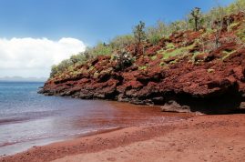
Often called the geographic center of the Galápagos archipelago, Rábida is predominantly composed of scoria, a particulate material created when hot lava meets sea water. Scoria has a high iron content, giving the island a red color. Rábida’s single volcano is extinct, but it left behind a legacy: a spectacle of tall, red cliffs and a red-sand beach; which when played against the teal waters, makes this island visually stunning.
Visitor Sites:
1) Rábida Beach: On these red sands, marine iguanas and a noisy colony of Galápagos sea lions attempt to rest in the shade of nearby caves. Brown pelicans make homes by the beach in saltbushes. Behind the beach is a lagoon where wading birds and white-cheeked pintail ducks feed. A short trail inland leads through Littoral and Arid Zone plants, such as palo santos, prickly pear cacti, and spiny bushes. Galápagos doves, Galápagos mockingbirds, yellow warblers, and several species of Darwin’s finches flitter in the vegetation, while blue-footed boobies and Nazca boobies linger in the cliffs. Snorkel along the rocks at the east end of the beach to encounter scores of nearshore and pelagic fish. Landing: Wet.
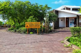
San Cristóbal is the easternmost and one of the oldest islands in the Galápagos, with eroded volcanic peaks in the north and densely vegetated slopes in the south. The provincial capital of the Galápagos, Puerto Baquerizo Moreno, lies at the head of Wreck Bay at the southwest tip of the island. One of the archipelago’s two airports is here (the other is on Baltra Island). In 1998, the Galápagos National Park Service opened the San Cristóbal Interpretation Center here, giving visitors the opportunity to learn more about the plants, ecosystems, wildlife, and human history of the archipelago.
San Cristóbal is the only island in the Galápagos with permanent freshwater, held in a small lake named El Junco near the top of the island. Because of this availability of water, the island was settled early in Galápagos history. In fact, Charles Darwin’s first stop in the Galápagos was on San Cristóbal in 1835 when the island was the home of the archipelago’s governor.

1) San Cristóbal Interpretation Center: The center, which is just outside of the town of Puerto Baquerizo Moreno, was opened in 1998 and features exhibits showcasing the natural and human history of the Galápagos and the ongoing efforts to preserve and protect the islands. Landing: None.
2) Cerro Tijeretas (Frigate Bird Hill): You can reach Cerro Tijeretas by following the trail behind the San Cristóbal Interpretation Center. Here, you can enjoy an impressive view of the bay and you may see both magnificent frigate birds and great frigatebirds in the same colony. The birds are not always present, so it’s best to speak with staff at the center before going. Landing: None.
3) Lobos Island: A narrow arm of seawater separates the basaltic rock outcropping of Isla Lobos from San Cristóbal. Rollicking sea lions and blue-footed boobies share the white sand beach. There are short hikes on the island and it is a great place to snorkel. Landing: Dry or wet.
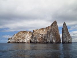
4) Kicker Rock: Rising several hundred feet above the water, this majestic volcanic monolith is one of the most photographed sites in the islands. Keep an eye on the cliffs for blue-footed and Nazca boobies and frigate birds. While there are no landing sites, Kicker Rock provides excellent snorkeling opportunities. You may see Galápagos and hammerhead sharks, spotted eagle rays, turtles and tropical fish. Landing: None.
5) Cerro Brujo (Witch Hill): There are no witches here, but the beautiful white sand beach, clear waters, abundant wildlife and Kicker Rock on the horizon make this landing spot bewitching nonetheless. Frolicking sea lions may greet you as you come ashore and you may see turtles, rays, anemones, and sponge coral if you opt to snorkel or swim. Keep an eye out for shore birds, gulls, pelicans, boobies, finches and mockingbirds. The site is often referred to as Witch Hill because of its distinctive volcanic tuft cone, which resembles a witch’s hat. Landing: Wet.
6) Punta Pitt: Disembarking on Punta Pitt, the easternmost point in the Galápagos, you’ll arrive on a mangrove-lined beach. After being greeted by a sea lion colony, you’ll discover the only place in Galápagos where all three types of boobies nest, alongside both types of frigate birds. A steep, 2.5-mile trail takes visitors up a cliff and through a ravine where abundant birdlife can be found. Landing: Wet.
7) El Junco Lagoon: From Puerto Baquerizo Moreno, you may take a taxi or a bus to the highlands to see the largest freshwater lake in the Galápagos, El Junco. Located about 400 feet above sea level, the lake is surrounded by ferns and sedges and hosts a variety of birdlife including white-cheeked pintails and common gallinules. The name El Junco comes from the junco plant, which is common in the area. Landing: None.
8.) Cerro Colorado Tortoise Reserve/La Galapaguera: A visitor site on the southeast part of San Cristóbal Island that can be reached in roughly one hour by road from Puerto Baquerizo Moreno. Established by the National Park in 2003, the Galapaguera is a man-made breeding program for tortoises and an information center for visitors. Visitors can both observe giant tortoises living in a semi-natural habitat, but also learn about their origin, evolution, and threats by introduced animals. On the trees and shrubs surrounding the site, you may see land birds like warbler, finches and mockingbirds, and on the trails, Giant Tortoises. Landing: Dry.
Geologically, Santa Cruz is an eroded island, with the oldest formations in the northeast. Human history here started in the twentieth century, when European and American settlers arrived between the two World Wars. The fertile soil of the tropical Moist Zones of the highlands saw the rise of the villages of Bellavista and Santa Rosa. With the settlers, however, came a great number of exotic plants and domestic animals, most of which turned feral and that then created a disastrous impact on the native species of the island. Cerro Colorado (the Red Rock) is a tectonically uplifted hill in which basaltic lava and fossiliferous tuff are layered with volcanic tuffs from the Miocene period. Santa Cruz is the home of the Charles Darwin Research Station (CDRS) and the Galápagos National Park (GNP). Santa Cruz is also the home of the largest lava tunnels in the Galápagos Islands and several reserves where you may encounter Galápagos giant tortoises in the wild.
Geologically, Santa Cruz is an eroded island, with the oldest formations in the northeast. Human history here started in the twentieth century, when European and American settlers arrived between the two World Wars. The fertile soil of the tropical Moist Zones of the highlands saw the rise of the villages of Bellavista and Santa Rosa. With the settlers, however, came a great number of exotic plants and domestic animals, most of which turned feral and that then created a disastrous impact on the native species of the island. Cerro Colorado (the Red Rock) is a tectonically uplifted hill in which basaltic lava and fossiliferous tuff are layered with volcanic tuffs from the Miocene period. Santa Cruz is the home of the Charles Darwin Research Station (CDRS) and the Galápagos National Park (GNP). Santa Cruz is also the home of the largest lava tunnels in the Galápagos Islands and several reserves where you may encounter Galápagos giant tortoises in the wild.
1) Puerto Ayora and the Charles Darwin Research Station: The Charles Darwin Research Station is about a ten-minute walk from the center of Puerto Ayora and is the operational center of the non-profit Charles Darwin Foundation, which conducts research and provides technical assistance to other researchers and governmental agencies, including the Galápagos National Park. Visitors can tour the Van Straelen Exhibition Center, where staff members are available to answer questions about the islands. Adjacent to the visitor center you will find the Fausto Llerena Tortoise Center, which began in 1965 to save the giant tortoise population on Pinzón, but soon expanded to include other populations, including Española, where only 14 individuals remained. The center has repatriated 4,000 tortoises to their islands of origin. You can observe 11 subspecies of tortoises here, ranging in age from hatchlings to juveniles to adults. Landing: Dry.
2) Tortuga Bay and Playa de los Perros: The one-mile walk to Tortuga Bay (the trail starts on Puerto Ayora’s Main Street) takes about an hour. It wends through the arid zone where many land birds can be spotted. The bay was named for the sea turtles that nest on the white sand beaches here. The long beach that faces the ocean has strong currents and is not recommended for swimming. The other beach lies on the north end of the bay and is a better place to swim. Species often spotted in the area include marine iguanas, flamingos (in the salt lagoon behind the mangroves) and white-tipped reef sharks. Playa de los Perros is a short beach on the westernmost point of Academy Bay. You must take an eight-minute water taxi ride from the municipal pier and then walk a few hundred yards to reach it. Landing: None.
3) El Mirador: El Mirador is located off the road to Baltra and can be reached by foot, bicycle or car. Many organized tour groups stop here, as it offers an interesting look at the volcanic forces that shaped the island. Lava tubes form when the surface layer of the lava flow cools upon contact with the air. The surface hardens as it cools and insulates the lava flowing beneath it, which prevents it from solidifying. The tube is located in an arid zone and is a good place to spot Darwin’s finches and owls. Landing: None.
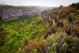
4) Los Gemelos: Los Gemelos (The Twins) are a pair of large pit craters on the road from Puerto Ayora to Baltra. The craters were created when the surface material covering empty magma chambers collapsed. You can walk along the rim of the craters and enjoy breathtaking views. The trail around the larger crater passes through a Scalesia forest and is good place to see a variety of bird species including Short-eared owls, Galápagos doves and vermillion flycatchers. Landing: None.
5) Media Luna (Half Moon) and Cerro Crocker (Crocker Hill): Starting in Bellavista, this hike to the highest point on the island leads past Media Luna, a half-moon shaped crater that is one of the primary nesting sites of the Galápagos petrel. It lies in the Miconia Zone, which is named for an endemic shrub species found exclusively in the highlands of Santa Cruz and San Cristóbal. The trail continues past Puntuda, a splatter cone, and Cerro Crocker, which is the highest point in on the island at about 2,400 feet. Here you can enjoy great views of the island and the ocean to the south. The area receives persistent rain for much of the year and the trails can be muddy. Bring sturdy hiking shoes, a raincoat, and stay on the trails to avoid getting lost and disturbing or destroying bird nests. Landing: None.
6) Santa Cruz Highlands: A journey from Puerto Ayora into the mist-covered forests of the highlands reveals the island’s diversity of landscapes and vegetation. Lush scalesia forests, wild tortoises, and half-mile long lava tubes create an otherworldly atmosphere here. Several farms allow visitors to go in search of the tortoises, which can also be seen at the nearby Tortoise Reserve. The forest surrounding the pond at El Chato is a good place to look for short-eared owls, Darwin’s finches, vermilion flycatchers, yellow warblers, Galápagos rails, and paint-billed Crakes. Landing: None.
7) Black Turtle Cove: The cove is located on the north coast of the island and is only accessible by boat. A quiet boat ride through the mangroves may reveal lava herons, sea turtles, spotted rays, and a variety of shark species, including black-finned reef sharks, white-tipped reef sharks, and Galápagos sharks. Landing: None.
8) Garrapatero: This long white beach is located approximately 12 miles northeast of Puerto Ayora. It is a 20-minute boat ride or 45 minutes by car from town. A trail (one half mile) from the parking area leads to a beautiful beach and lagoon, where flamingos are sometimes seen. Landing: None.
9.) Carrion Point: Carrion Point creates a sheltered lagoon with beautiful, turquoise water. During this visit, you can snorkel and see a variety of fish, rays and perhaps the harmless white-tip reef sharks. The point is on the north coast of Santa Cruz Island at the entrance of Channel of Itabaca. Landing: None.
10) Las Bachas Beach: Las Bachas Beach is located in the north of Santa Cruz Island. It’s soft, white sand is derived from decomposed coral, making it a favorite nesting site for sea turtles. Behind the beach, there is a small brackish lagoon, where it is possible to observe flamingos and other coastal birds, such as black-necked stilts and whimbrels. Landing: Wet.

Santa Fé Island is an uplift where some of the oldest basaltic rocks of the archipelago — 2.7 million years — have been dated. It is one of the most picturesque anchorages within the Galápagos. On a sunny day, the bay of Santa Fé turns a brilliant turquoise-blue, and rows of sleeping Galápagos sea lion cows and pups make a beach walk entrancing. Often the Santa Fé land iguanas can be seen beneath the imposing prickly pear cacti that are also unique to this island. Their height (over twenty feet) is an adaptive mechanism to protect them from the land iguanas and giant tortoises (now extinct on Santa Fé), and they are more heavily trunked than any other in the islands.
1) Barrington Bay: The visitor site on Santa Fé is sometimes called Barrington Bay. A visit begins with a wet landing on a small beach. The beaches here are popular with sea lions, which can often be seen surfing the waves. There are two visitor trails here; one leading to a scenic viewpoint atop a cliff, and the other wending through a forest of massive Santa Fe opuntia cactus. Snorkeling in the radiant blue-green waters is excellent, and you may see a Galápagos green turtle gracefully swim by. Landing: Dry.
Once a favorite island of pirates and whalers, Santiago is now appreciated for its Galápagos fur seal grotto and newly plant-colonized lava flow on the southern coast. Northwest of Santa Cruz Island, Santiago Island is composed of a number of tuff cones and a central volcano. The vegetation is dense in the highlands, and a scalesia forest covers the northwest side of the volcano.

1) Puerto Egas: At the southern end of the bay James Bay lays Puerto Egas. It is the jumping off point for two trails. The first leads to fur seal grottos – a stretch of rocky coastline that offers them shade and protection. The second trail leads to the Salt Mine Volcano, a small crater that features a seasonally flooded lagoon, where flamingos and Galápagos hawks can sometimes be spotted. A salt mine was active here in the 1920s and 1960s. Landing: Wet.
2) Espumilla Beach: This beach lies at the north end of James Bay. It is fringed by beautiful palo santo forest and is a sea turtle nesting site. It is a good place to see marine iguanas and colorful Sally Lightfoot crabs and it is an excellent place to snorkel. Marine life here includes octopi, moray eels, and sharks. From the beach, you can take a loop trail inland to a seasonal lagoon where flamingos are sometimes spotted. The trail winds through an arid zone where you may spot a variety of land birds. Landing: Wet.
3) Buccaneer Cove: In the 1600s and 1700s, Buccaneer Cove was a haven for pirates, who would anchor in the protected bay to stock up on tortoises and firewood and to repair their ships. This is often a cruise-by point, due to the sometimes wet and unsafe landing conditions. But keep an eye on the cliffs above for sea birds. The cove is home to sea lions and can be a good place to snorkel. Landing: Wet.
4) Sullivan Bay: While it doesn’t boast much wildlife, Sullivan Bay provides visitors with an opportunity to walk across a recent lava flow and examine its otherworldly beauty. Don’t worry; the lava isn’t hot, as it was formed in the late 19th century. The trail here crosses pahoehoe lava, dotted with pyroclastic cones. Inland, striking red and yellow tuft cones rise above the flow. Keep an eye out for tiny molluga plants growing in the lava fissures. Landing: Dry.
Just off the southeastern tip of Santiago Island, lies the tiny Sombrero Chino (or “Chinese Hat”). Named for its distinctive profile, Sombrero Chino is separated from the bigger island by a light-blue-green lagoon. The island is the classic example of a place with a volcanic origin: The “land” is made of a few adjacent craters and very old, fragile pahoehoe lava flows. As a result, vegetation is just starting to take hold. Colorful carpetweed plants are scattered here and there.
1) Sombrero Chino Beach: The trail on the island runs from the landing site on the northern white-sand beach — where you may see Galápagos penguins, Galápagos sea lions, and Sally Lightfoot crabs — to the rocky shore of the western part of the island. Here, you’ll enter a primeval world of volcanic rubble, sharp outcroppings, and lava formations. Marine iguanas wallow in tide pools and relish a spray of mist as the waves crash against the nearby rocks. From the top of the island, Galápagos hawks monitor their kingdom. The lava fields here will break beneath your feet and are so fragile that the Galápagos National Park has deemed this site to be sensitive to the impact of tourism. After your land visit, there is usually an opportunity to go snorkeling in the lagoon. Landing: Wet.
Created from uplifted submarine lava, South Plaza Island is a not-to-be-forgotten experience, since it is one of the most concentrated wildlife sites in the Galápagos. Along with a colony of land iguanas is a marine iguana colony. You may see a hybrid of the two species: one whose father is a marine iguana and whose mother is a land iguana.
1) South Plaza: After a dry landing at a small dock — where you are almost always met by a few Galápagos sea lions — the trail will lead you through a combined Littoral and Arid Zone, which contains a “forest” of prickly pear cacti and their yellow flowers. Here, you’ll find land iguanas feasting on the ample food. A cactus finch will sometimes hop on the back of a land iguana, which then stretches up on all fours, allowing the finch free access to do some “cleaning.”
After traveling through extensive patches of salt-tolerant, brilliant red-orange Galápagos carpetweed (which turns green with rainfall), you’ll approach the sea cliffs. Red-billed tropicbirds with their long, white tail streamers and Galápagos shearwaters whistle and shriek overhead as they fight the offshore winds to find their homes in the crevices along overhanging ledges. Blue-footed boobies and Nazca boobies launch into the air from the rocks, where the updraft makes soaring easier. Swallowtail gulls court, mate, and raise chicks here. Look down, and you may spot mullet feeding on the surface of the water. At the end of the walk along the cliff is a Galápagos sea lion colony of bachelors, a battle-scarred group of old and young bulls lounging in the sun far above the ocean.
Following the dry landing at the dock and the walk along the trail, there is often an opportunity to go swimming and snorkeling from the beach. Landing: Dry.